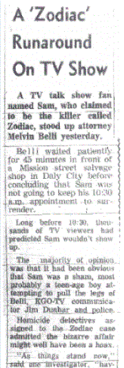
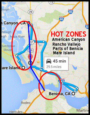
Kim Rossmo is a Canadian criminologist who specializes in geographic profiling to narrow down an offenders likely home location and uses his skills to formulate an extensive analysis of the Zodiac attacks from December 20th 1968 to October 11th 1969. Despite there being only four locations to work with, he coalesced the wording used in the Zodiac letters, crime scene evidence and travel routes to pinpoint hot zones where our killer most likely resided. Using the computer software Rigel, color coded schematics can be generated to visually represent these areas of interest. This, combined with what we already know about the killer, can help to prioritize our search fields before extending outwards - however, as Kim Rossmo alludes, the art of geographical profiling techniques are a complimentary tool to assist the investigator, rather than a point of beginning.
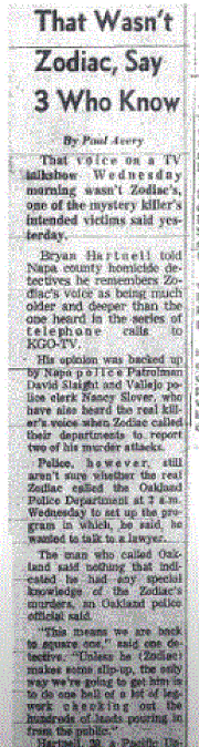
His detailing on the Zodiac crimes are second to none and can provide anybody, whether experienced or new to the case, the perfect reading material to form a solid foundation on the decisions the Zodiac Killer may have been confronted with back in the Northern California of 1968 and 1969. To view this comprehensive analysis of the Zodiac crimes click here. When he entered the details of the Zodiac crimes into Rigel, hot zones on a map were revealed, that included the North West of Vallejo, Rancho Vallejo, Mare Island and some areas of Benicia. But here I would like to focus on the travel routes, that may have been instrumental to everything the killer did, when he not only chose his attack locations, but his escape routes and the placement of his phone calls after the Blue Rock Springs Park and Lake Berryessa attacks.
His detailing on the Zodiac crimes are second to none and can provide anybody, whether experienced or new to the case, the perfect reading material to form a solid foundation on the decisions the Zodiac Killer may have been confronted with back in the Northern California of 1968 and 1969. To view this comprehensive analysis of the Zodiac crimes click here. When he entered the details of the Zodiac crimes into Rigel, hot zones on a map were revealed, that included the North West of Vallejo, Rancho Vallejo, Mare Island and some areas of Benicia. But here I would like to focus on the travel routes, that may have been instrumental to everything the killer did, when he not only chose his attack locations, but his escape routes and the placement of his phone calls after the Blue Rock Springs Park and Lake Berryessa attacks.
 Click to enter Google Maps
 One extremely interesting point Kim Rossmo brought up was 'search attempts', in that it was highly likely the Zodiac Killer, being a hunter, had many failed search attempts before he finally secured his eventual victims. We do not know with any certainty that the Zodiac would not have struck at Lake Herman Road for a second time on July 4th 1969, had he been granted the opportunity, or vice versa with Blue Rock Springs being his first crime on December 20th 1968. Without evidence that these couples were followed to these destinations, they appeared opportunistic, with the killer seemingly familiar with these locations as 'lovers lane' areas - both being secluded, with the possibility of escaping the crime scene undetected.
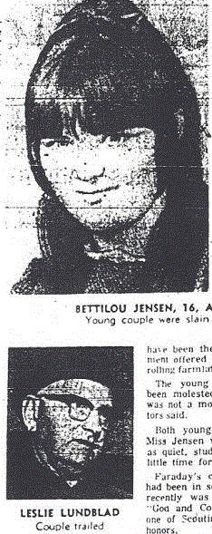
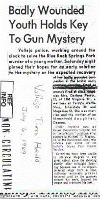
We know that at approximately 9:30 pm on the night of December 20th 1968, William Crow and his girlfriend were parked in the gravel turnout, in which David Faraday and Betty Lou Jensen were later killed, and claimed he was followed by a car, possibly a blue Valiant, stating "I gunned our car out of there. The other driver followed me - I couldn't say he was actually chasing us because he never gained on us. I turned off towards Benicia and he turned in the opposite direction. As far as I was concerned he went on, that was the end of it until I read Saturday what had happened in the same spot where we were, and then I started thinking all the more about it".
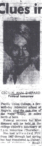
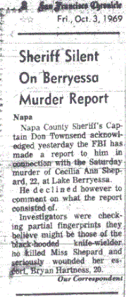
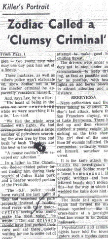
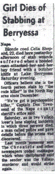
We also know that Bingo Wesher, a sheepherder, reported seeing a white Chevrolet parked up in the turnout at around 10:00 pm. Of course, these may or may not be related to the Zodiac Killer - one can only speculate - but it seems highly probable that the killer of David Faraday and Betty Lou Jensen may well have been scouring the area for some time before the opportunity arose. This may have been the case at Lake Berryessa, when three sunbathing girls described a suspicious character in the preceding hours to the attack on Bryan Hartnell and Cecelia Shepard on September 27th 1969.
But in the Presidio Heights murder of Paul Stine on October 11th 1969, Kim Rossmo explains that the killer exhibited target selection, as opposed to his first three crimes, where the location was the overriding consideration. If we believe the Zodiac Killer to be a resident of Vallejo or Benicia and less familiar with the San Francisco area, then control would be the order of the day and his 'search attempts' in alien surroundings are less certain. He could not afford to travel around looking for victims without designated prime locations and expect to escape with any surety, thereby he targeted the victim first, as opposed to the location being the prime requisite. In the Lake Herman Road and Blue Rock Springs attacks he frequented known locations to find a victim, whereas in San Francisco he searched for a victim and took him to a location. Kim Rossmo states that 'criminals who travel longer distances to offend are less likely to use uncertain target selection techniques'.
We know that at approximately 9:30 pm on the night of December 20th 1968, William Crow and his girlfriend were parked in the gravel turnout, in which David Faraday and Betty Lou Jensen were later killed, and claimed he was followed by a car, possibly a blue Valiant, stating "I gunned our car out of there. The other driver followed me - I couldn't say he was actually chasing us because he never gained on us. I turned off towards Benicia and he turned in the opposite direction. As far as I was concerned he went on, that was the end of it until I read Saturday what had happened in the same spot where we were, and then I started thinking all the more about it".
We also know that Bingo Wesher, a sheepherder, reported seeing a white Chevrolet parked up in the turnout at around 10:00 pm. Of course, these may or may not be related to the Zodiac Killer - one can only speculate - but it seems highly probable that the killer of David Faraday and Betty Lou Jensen may well have been scouring the area for some time before the opportunity arose. This may have been the case at Lake Berryessa, when three sunbathing girls described a suspicious character in the preceding hours to the attack on Bryan Hartnell and Cecelia Shepard on September 27th 1969.
But in the Presidio Heights murder of Paul Stine on October 11th 1969, Kim Rossmo explains that the killer exhibited target selection, as opposed to his first three crimes, where the location was the overriding consideration. If we believe the Zodiac Killer to be a resident of Vallejo or Benicia and less familiar with the San Francisco area, then control would be the order of the day and his 'search attempts' in alien surroundings are less certain. He could not afford to travel around looking for victims without designated prime locations and expect to escape with any surety, thereby he targeted the victim first, as opposed to the location being the prime requisite. In the Lake Herman Road and Blue Rock Springs attacks he frequented known locations to find a victim, whereas in San Francisco he searched for a victim and took him to a location. Kim Rossmo states that 'criminals who travel longer distances to offend are less likely to use uncertain target selection techniques'.
 Click here to enter Google Maps
 Kim Rossmo speculated that the most likely place the Zodiac Killer would have parked his vehicle, was between West Pacific Avenue and Locust Street, or Jackson and Spruce Street. An exit strategy over the Golden Gate Bridge via U.S Route 101 immediately separates the Zodiac Killer from the heart of the action, eventually converging with State Route 37, straight to the northwest region of Vallejo.
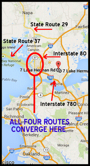
Interstate 80 traverses the Carquinez Strait, passes through the Richmond, Berkeley and Oakland areas to San Francisco.
Interstate 780 connects the lower regions of Benicia and Vallejo.
State Route 29 passes through Vallejo to American Canyon, Napa County and close to Lake Berryessa.
Three of these routes converge in close proximity to the southern region of Vallejo, see here, with State Route 37 further north - but still within the Vallejo boundary. All of which provide easy access routes to and from San Francisco, Lake Berryessa, Blue Rock Springs Park and Lake Herman Road. This must have been a consideration for the Zodiac Killer to make good his escape from the scenes of crime. The 40 minute difference between the Blue Rock Springs attack and the phone call at Springs Road and Tuolumne, if we assume he traveled home to conceal the weapon, restricts the Zodiac's residency within this region.
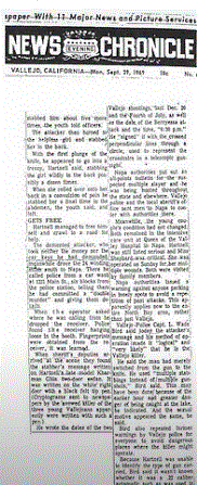
Based on the eyewitness testimonies of James Owen and Stella Borges after the Lake Herman Road murders, it was believed the Zodiac Killer must have headed east to Benicia, however, if these timelines are out by just a few minutes, the window opens up, to allow the Zodiac Killer to head in the direction of Columbus Parkway in Vallejo. After the Blue Rock Springs Park attack he was also believed to have headed this way - and in both instances, after reaching Tennessee Street and continuing westwards, he would pass very close to the Springs and Tuolumne payphone. This familiarity may have played a decisive factor when he decided to place his first phone call to police dispatcher Nancy Slover.
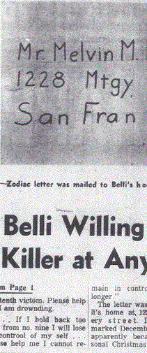
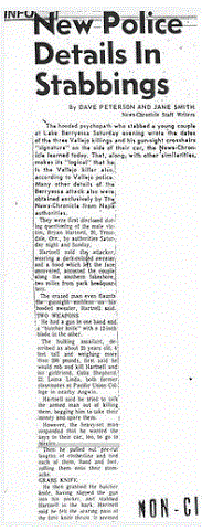
Tennessee Street continues on and passes by State Route 29 - the route that would have taken him from Lake Berryessa, through Napa, where he placed his second phone call to police dispatcher Dave Slaight, right into the heart of Vallejo. Interstate 80 bisects Tennessee Street, and California State Route 37 from San Francisco is close by. See here. If we assume that the Zodiac Killer applied caution after the Blue Rock Springs attack and went home to ditch his weapon, then it is easy to see why American Canyon and Benicia are highlighted by the Rigel software, as both journeys are roughly 30 minutes traveling time, with a turnaround time of 10 minutes, making the phone call possible in both instances. Any further and the timeline becomes strained. Of course, there is no guarantee that the Zodiac Killer lived in this region, but as Kim Rossmo states "all things being equal, suspects located there should be prioritized". Unfortunately for us, the highest profile suspect, that of Arthur Leigh Allen, did live in Vallejo during the first two attacks at Lake Herman Road and Blue Rock Springs Park, at 32 Fresno Street, and within walking distance of the payphone at the Springs Road and Tuolumne intersection. But he would be later ruled out using DNA and fingerprint analysis - so the search goes on.
Interstate 80 traverses the Carquinez Strait, passes through the Richmond, Berkeley and Oakland areas to San Francisco.
Interstate 780 connects the lower regions of Benicia and Vallejo.
State Route 29 passes through Vallejo to American Canyon, Napa County and close to Lake Berryessa.
Three of these routes converge in close proximity to the southern region of Vallejo, see here, with State Route 37 further north - but still within the Vallejo boundary. All of which provide easy access routes to and from San Francisco, Lake Berryessa, Blue Rock Springs Park and Lake Herman Road. This must have been a consideration for the Zodiac Killer to make good his escape from the scenes of crime. The 40 minute difference between the Blue Rock Springs attack and the phone call at Springs Road and Tuolumne, if we assume he traveled home to conceal the weapon, restricts the Zodiac's residency within this region.
Based on the eyewitness testimonies of James Owen and Stella Borges after the Lake Herman Road murders, it was believed the Zodiac Killer must have headed east to Benicia, however, if these timelines are out by just a few minutes, the window opens up, to allow the Zodiac Killer to head in the direction of Columbus Parkway in Vallejo. After the Blue Rock Springs Park attack he was also believed to have headed this way - and in both instances, after reaching Tennessee Street and continuing westwards, he would pass very close to the Springs and Tuolumne payphone. This familiarity may have played a decisive factor when he decided to place his first phone call to police dispatcher Nancy Slover.
Tennessee Street continues on and passes by State Route 29 - the route that would have taken him from Lake Berryessa, through Napa, where he placed his second phone call to police dispatcher Dave Slaight, right into the heart of Vallejo. Interstate 80 bisects Tennessee Street, and California State Route 37 from San Francisco is close by. See here. If we assume that the Zodiac Killer applied caution after the Blue Rock Springs attack and went home to ditch his weapon, then it is easy to see why American Canyon and Benicia are highlighted by the Rigel software, as both journeys are roughly 30 minutes traveling time, with a turnaround time of 10 minutes, making the phone call possible in both instances. Any further and the timeline becomes strained. Of course, there is no guarantee that the Zodiac Killer lived in this region, but as Kim Rossmo states "all things being equal, suspects located there should be prioritized". Unfortunately for us, the highest profile suspect, that of Arthur Leigh Allen, did live in Vallejo during the first two attacks at Lake Herman Road and Blue Rock Springs Park, at 32 Fresno Street, and within walking distance of the payphone at the Springs Road and Tuolumne intersection. But he would be later ruled out using DNA and fingerprint analysis - so the search goes on.


 RSS Feed