 Kathleen Johns
 If the Zodiac Killer was a resident of San Francisco, Vallejo, Benicia or some nearby location, then his actions of traveling 160 to 180 miles round trip, solely for the purpose of abducting a woman at 11:15 pm at night, may appear a little extreme. This lays down a buffer zone of at least 90 miles from Vallejo. The idea of cruising around Highway 132, west of Modesto primarily for the purpose of hopefully encountering a suitable vehicle and occupant, at near midnight, appears a bit random for a killer who targeted locations. Unless of course, this wasn't his primary reason for being in the area that night and his abduction of Kathleen Johns was secondary and spur of the moment. This article will explore further the military angle and the premise that the Zodiac Killer was returning back to the Bay Area on March 22nd 1970, before chance intervened and the night took on an unexpected turn, as Kathleen Johns vehicle drove right across Zodiac's line of sight.
I recently contacted the FBI under the Freedom of Information Act to release the names held on this document, involving a suspect stationed in either the US Army or US Air Force in San Francisco, Riverside and Patterson. Unfortunately it was denied "The one page document that was released on the Vault was processed pursuant to the current Attorney General guidelines, therefore do not qualify for reprocessing at this time. For your information, Congress excluded three discrete categories of law enforcement and national security records from the requirements of the FOIA".
The following is an extension to the article Crows Landing and the Modesto Abduction expanding it just a little further. In particular, regarding the Alameda Naval Air Station bordering the eastern side of San Francisco. (shown here on Google Maps in relation to Pleasanton, which is located in Alameda County)
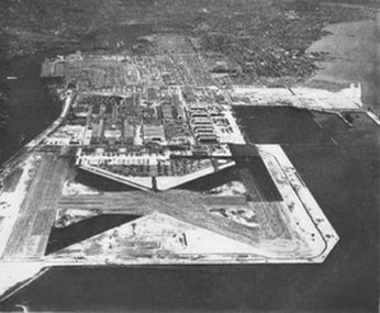 Alameda Naval Air Station
 Almost everybody, including the Zodiac Killer, employ what is known as the least effort principle, that suggests a person will take the option of using less energy to accomplish a necessary task. In the case of mailing his correspondence, the killer certainly does not want to reveal key information about his home or work location from a standpoint of geographical profiling, but over time complacency and laziness can kick in, and mistakes can be made.
On March 13th 1971, the Zodiac Killer mailed the 'Los Angeles' letter from Pleasanton, Alameda County. The SLA letter was mailed on February 3rd 1974 from Los Angeles County. The following correspondence on May 8th 1974 was the 'Citizen Card', postmarked again from Alameda County, and finally came the 'Red Phantom' letter, postmarked San Rafael, Marin County on July 8th 1974. It is open to debate whether the later mailings were from the Zodiac Killer, but the 'Los Angeles' letter and 'Citizen Card' were both mailed from the same county despite a three year hiatus. But they all have another thing in common - that being Interstate 580 - which passes through Pleasanton, Alameda, the Naval Station and San Rafael in a direct route. It is almost as though the Zodiac Killer mailed them for convenience on his travels. See here on Google Maps.
Crucially though, Interstate 580 (an 80 mile highway) travels down alongside Tracy, California and the area where it is claimed the Zodiac Killer drove Kathleen Johns around for 1 or 2 hours, before she finally managed to escape near the vineyards alongside Bird Road. Interstate 580 joins up with Interstate 5 by Patterson, California, shown here on Google Maps, and the location of the police station where Kathleen Johns was taken after her apparent abduction. Kathleen Johns would recall that within the car, described as messy, she had noticed men's and children's clothing scattered about, books and papers, a black rubber handled flashlight and two colored plastic scouring pads on the console dashboard. Kathleen estimated that the smaller patterned T-shirts were of the age range 8 to 12 years. She described her abductor as white, about 30 years, 5'9" in height, 160 lbs, dark hair and clean-cut, having the traits of a serviceman. During her ordeal in the car she recalled his highly polished shoes that reflected the yellow lights from the car interior, likening them to Navy shoes. Not only is the area of Patterson mentioned in the FBI files above, but the military connection may be crucial regarding the abduction of Kathleen Johns, as well as the I-5 and I-580, and the Alameda Naval Air Station, that also has a connection to Patterson.
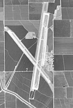 Aerial view of NASA Crows Landing
 Running right by NASA Crows Landing is Interstate 5, which then intersects with Highway 132 only 24 miles north (a journey of 22 minutes by car). In fact, Interstate 5 joins Highway 132 (the route Kathleen Johns fatefully took that night) only 0.8 miles shy of where she was abducted and ultimately where her car was found burnt out, near Bird Road. The quickest route from NASA Crows Landing back to the Bay Area using main transport links, would be to travel north on Interstate 5, taking Interstate 580 on the western edge of Tracy, head west to Pleasanton, northwest to Alameda, passing Alameda Naval Base and continuing northwest to San Rafael. The latter of which all skirt the San Francisco Bay Area and more importantly, where the Zodiac Killer mailed three of his letters from 1971 onward. View on Google Maps.
If the Zodiac Killer was of military persuasion, responsible for the abduction of Kathleen Johns, and linked to the Patterson area via an auxiliary base, then it is easy to see how the Zodiac Killer, believing he was "crackproof", may have employed the least effort principle and mailed his correspondence en route to and from work, via the areas he passed through. Or was the Zodiac Killer trying to throw investigators off the trail by mailing his correspondence, outside of San Francisco, from different areas, but inadvertently had left a trail of breadcrumbs along Interstate 580? In respect to the later mailings and Interstate 580, a possible connection exists - but it was brief and possibly too small a sample to draw anything conclusive.
The Halloween card mailed on October 27th 1970 threatening a fourteenth victim, coincided with the disappearance of Phyllis O'Brien Carson (32), from the Francis Truck Stop, French Camp, San Joaquin County, California. French Camp lies only 15 miles from Tracey and 23 miles from Interstate 580. Unfortunately, Phyllis O'Brien Carson's body was discovered just over three weeks later on November 21st 1970. http://www.zodiacciphers.com/zodiac-news/east-of-pleasanton


 RSS Feed
