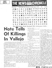
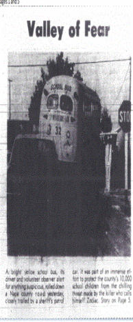
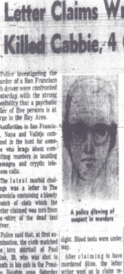
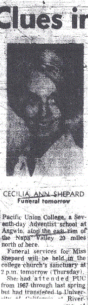
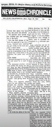
In a previous article it was shown how the Zodiac Killer began mailing his later correspondence further afield, beginning on March 13th 1971, when the Zodiac Killer mailed the 'Los Angeles' letter from Pleasanton, Alameda County. This was followed by the 1974 letters, including the 'Citizen Card', again mailed from Alameda County, along with the 'Red Phantom' letter, postmarked San Rafael, Marin County on July 8th 1974. All had Interstate 580 in common, suggesting that the Zodiac Killer may have been mailing his letters to and from particular locations, that tied in with the military bases of Alameda Naval Air Station and Naval Auxiliary Field Crows Landing - the latter of which is situated only 24 miles from the intersection of Highway 132 and Interstate 5, the area where Kathleen Johns was abducted on March 22nd 1970. The connection we were trying to formulate was a military angle, the killer's reasons for being at specific locations at particular times and murders that took place close by to certain major travel routes. The killer, if murdering on the fly, needs ease of access and egress if at all possible, especially when you have avoided near capture, as experienced on October 11th 1969. To catch up on the previous article visit http://www.zodiacciphers.com/zodiac-news/en-route-to-san-francisco
 Click to enter Google Maps
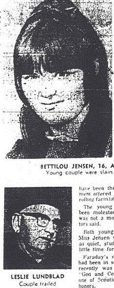
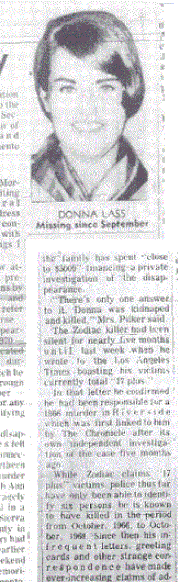
 The Zodiac Killer appeared to cease his murderous rampage by 1970, yet there were four murders, one abduction and a missing woman (likely murdered), all along one particular route - that of Interstate 5 and Interstate 80, which directly spans South Bird Road (the area of Kathleen Johns abduction), to the area where Donna Lass went missing from Stateline, Nevada on September 6th 1970, having finished her shift that day at the Sahara Tahoe Hotel. There were three murders in Sacramento.
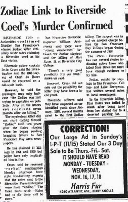
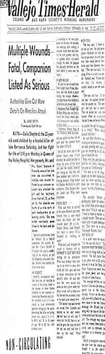
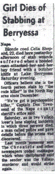
Judith Hakari was a nurse at Sutter Hospital, who disappeared heading back to the Markston Apartments on March 7th 1970. Her body was later discovered by Ponderosa Way in Weimar, forty two miles away, along Interstate 80. Nancy Bennallack was murdered on October 25th 1970 in her apartment, just a stone's throw from where Judith Hakari lived, near Glendale Lane. Carol Beth Hilburn was murdered on November 14th 1970, last seen on Del Paso Boulevard and found on Ascot and 4th Street. These two areas are bisected by Interstate 80. Sandwiched in between these murders were the two abductions of Donna Lass and Kathleen Johns.
If we look at the relevant areas off Interstate 5 and Interstate 80, then we notice certain key features.
The site of Kathleen Johns abduction and where her vehicle was discovered burnt out, is only 1 mile or 2 minutes traveling time from Interstate 5. The residence of Judith Hakari and the area her body was discovered, not only were situated alongside Interstate 80, but Ponderosa Way is only 2 miles or 5 minutes from Interstate 80, and the Markston Apartments only 4 miles or 8 minutes from Interstate 80. Regarding Carol Beth Hilburn, Del Paso Boulevard is only 2.2 miles or 5 minutes traveling time to Interstate 80, and Ascot and 4th Street only 3 miles or 7 minutes from Interstate 80.
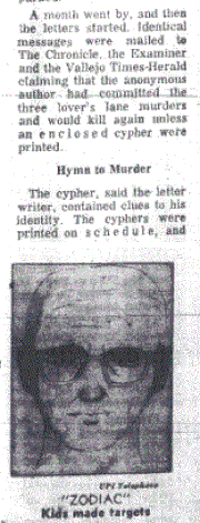
Interstate 80 continues on to Lake Tahoe, near the area where Donna Lass went missing on September 6th 1970. Six and a half months after her disappearance, the Pines card was mailed to the San Francisco Chronicle, purportedly from the Zodiac Killer. The search for Donna Lass was badly affected by the inclement weather in the months after her disappearance, highlighted by Police Chief Ray Lauritzen from the outset "We don't know where we're going to begin. There's a four or five foot pack of snow out there and it's still snowing heavily". The Pines Card made reference to the snow, but in a sinister way inferred Donna Lass may be buried under it - hence the phrase 'around in the snow' being placed at ground level and pasted upside down. In a newspaper article it stated that the site depicted on the Pines Card was from an advertisement published the previous Sunday by several newspapers. It was an artist's rendition of houses among the trees at a project at Incline Village, near Clair Tappaan Lodge, Norden, California - the address of which happens to be 19940 Donner Pass Road. Whether this name and that of the missing woman is a coincidence is unknown. But again, Clair Tappaan Lodge is situated right alongside Interstate 80, only 2.3 miles or 4 minutes by car, suggesting somebody traveling this route would likely have been familiar with this area and may well, as the 'Pines Card' suggested, held clues to a burial site.
On December 27th 1974, a Christmas card was mailed to Mary Pilker, Donna Lass' sister, portraying trees covered in snow. Once opened it revealed a message that was part of the card itself - 'Holiday Greetings and Best Wishes for a Happy New Year', followed by the handwriting "Best Wishes, St Donna & Guardian of the Pines".
Judith Hakari was a nurse at Sutter Hospital, who disappeared heading back to the Markston Apartments on March 7th 1970. Her body was later discovered by Ponderosa Way in Weimar, forty two miles away, along Interstate 80. Nancy Bennallack was murdered on October 25th 1970 in her apartment, just a stone's throw from where Judith Hakari lived, near Glendale Lane. Carol Beth Hilburn was murdered on November 14th 1970, last seen on Del Paso Boulevard and found on Ascot and 4th Street. These two areas are bisected by Interstate 80. Sandwiched in between these murders were the two abductions of Donna Lass and Kathleen Johns.
If we look at the relevant areas off Interstate 5 and Interstate 80, then we notice certain key features.
The site of Kathleen Johns abduction and where her vehicle was discovered burnt out, is only 1 mile or 2 minutes traveling time from Interstate 5. The residence of Judith Hakari and the area her body was discovered, not only were situated alongside Interstate 80, but Ponderosa Way is only 2 miles or 5 minutes from Interstate 80, and the Markston Apartments only 4 miles or 8 minutes from Interstate 80. Regarding Carol Beth Hilburn, Del Paso Boulevard is only 2.2 miles or 5 minutes traveling time to Interstate 80, and Ascot and 4th Street only 3 miles or 7 minutes from Interstate 80.
Interstate 80 continues on to Lake Tahoe, near the area where Donna Lass went missing on September 6th 1970. Six and a half months after her disappearance, the Pines card was mailed to the San Francisco Chronicle, purportedly from the Zodiac Killer. The search for Donna Lass was badly affected by the inclement weather in the months after her disappearance, highlighted by Police Chief Ray Lauritzen from the outset "We don't know where we're going to begin. There's a four or five foot pack of snow out there and it's still snowing heavily". The Pines Card made reference to the snow, but in a sinister way inferred Donna Lass may be buried under it - hence the phrase 'around in the snow' being placed at ground level and pasted upside down. In a newspaper article it stated that the site depicted on the Pines Card was from an advertisement published the previous Sunday by several newspapers. It was an artist's rendition of houses among the trees at a project at Incline Village, near Clair Tappaan Lodge, Norden, California - the address of which happens to be 19940 Donner Pass Road. Whether this name and that of the missing woman is a coincidence is unknown. But again, Clair Tappaan Lodge is situated right alongside Interstate 80, only 2.3 miles or 4 minutes by car, suggesting somebody traveling this route would likely have been familiar with this area and may well, as the 'Pines Card' suggested, held clues to a burial site.
On December 27th 1974, a Christmas card was mailed to Mary Pilker, Donna Lass' sister, portraying trees covered in snow. Once opened it revealed a message that was part of the card itself - 'Holiday Greetings and Best Wishes for a Happy New Year', followed by the handwriting "Best Wishes, St Donna & Guardian of the Pines".
 December 27th 1974 Christmas card
 Here is the card and here is the street view in winter from Donner Pass Road, outside Clair Tappaan Lodge.
On the 'Pines Card' mailed on March 22nd 1971, text on the card read; [1] 'Sierra Club' [2] 'Sought Victim 12' [3] 'Peek through the pines' [4] 'pass Lake Tahoe areas' [5] 'around in the snow' (pasted upside down).
If we were reading hidden clues from this correspondence and searching for a possible burial site, then we have to follow its directions from the last sighting of Donna Lass at the Sahara Tahoe Hotel and Casino, and head towards the Clair Tappaan Lodge and the Sierra Club.
California State Route 89 skirts the western shores of Lake Tahoe towards Truckee, California and passes many 'Lake Tahoe Areas' en route. It finally joins Interstate 80 only 1.5 miles or 3 minutes from Donner Memorial State Park, in memory of the ill fated Donner Party.
Again, whether this was Zodiac's intention to direct us to a 'Donner Memorial' using a play on words, is sheer speculation.
But this area and the site of Clair Tappaan Lodge would certainly lend weight to the phrase 'Peek through the pines', as the lodge is literally yards from Donner Pass Road.
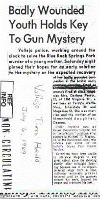
This brings us to the disappearance and ultimate murder of Phyllis O'Brien Carson on October 27th 1970 - a significant Zodiac date regarding the Halloween Card. Phyllis O'Brien Carson (32) was a young mother of four children, last seen after a night out at the Francis Truck Stop, French Camp, San Joaquin County, California. French Camp is a small community situated approximately ten minutes drive south of the town of Stockton CA and fifteen minutes north of Manteca CA. Since the construction of California State Route 120, Manteca had become a popular choice for workers from the main towns and cities, along with the Bay Area, as rising house prices forced people to search for cheaper alternatives. Interstate 5 and State Route 99 are integral commuter routes through California, with the I-5 the main highway on the west coast of America, linking to San Diego, Los Angeles and Sacramento. San Francisco lies 80 miles and a one-hour twenty minute drive due west from French Camp.
Phyllis had visited the popular bar, along with her brother and sister on October 27th 1970 - and later on during the evening placed a phone call to her home residence to check on her children, stating she was to receive a lift home from a friend. Sadly for Phyllis O'Brien Carson and her family, her journey home was never realized. She had vanished without a trace - that is until family members received the heartbreaking news just over three weeks later, on November 21st 1970, that her body had been discovered laying down an embankment near to Yettner Road, only five miles from the family residence. The cause of death and perpetrator remain unknown, but foul play was certain, as her body was partially clothed and seemingly thrown from a vehicle. However, robbery was apparently ruled out, as her belongings appeared untouched. Nobody from the bar has ever come forward to this day with a name of the mystery friend that Phyllis was supposed to have left with that night.
On the 'Pines Card' mailed on March 22nd 1971, text on the card read; [1] 'Sierra Club' [2] 'Sought Victim 12' [3] 'Peek through the pines' [4] 'pass Lake Tahoe areas' [5] 'around in the snow' (pasted upside down).
If we were reading hidden clues from this correspondence and searching for a possible burial site, then we have to follow its directions from the last sighting of Donna Lass at the Sahara Tahoe Hotel and Casino, and head towards the Clair Tappaan Lodge and the Sierra Club.
California State Route 89 skirts the western shores of Lake Tahoe towards Truckee, California and passes many 'Lake Tahoe Areas' en route. It finally joins Interstate 80 only 1.5 miles or 3 minutes from Donner Memorial State Park, in memory of the ill fated Donner Party.
Again, whether this was Zodiac's intention to direct us to a 'Donner Memorial' using a play on words, is sheer speculation.
But this area and the site of Clair Tappaan Lodge would certainly lend weight to the phrase 'Peek through the pines', as the lodge is literally yards from Donner Pass Road.
This brings us to the disappearance and ultimate murder of Phyllis O'Brien Carson on October 27th 1970 - a significant Zodiac date regarding the Halloween Card. Phyllis O'Brien Carson (32) was a young mother of four children, last seen after a night out at the Francis Truck Stop, French Camp, San Joaquin County, California. French Camp is a small community situated approximately ten minutes drive south of the town of Stockton CA and fifteen minutes north of Manteca CA. Since the construction of California State Route 120, Manteca had become a popular choice for workers from the main towns and cities, along with the Bay Area, as rising house prices forced people to search for cheaper alternatives. Interstate 5 and State Route 99 are integral commuter routes through California, with the I-5 the main highway on the west coast of America, linking to San Diego, Los Angeles and Sacramento. San Francisco lies 80 miles and a one-hour twenty minute drive due west from French Camp.
Phyllis had visited the popular bar, along with her brother and sister on October 27th 1970 - and later on during the evening placed a phone call to her home residence to check on her children, stating she was to receive a lift home from a friend. Sadly for Phyllis O'Brien Carson and her family, her journey home was never realized. She had vanished without a trace - that is until family members received the heartbreaking news just over three weeks later, on November 21st 1970, that her body had been discovered laying down an embankment near to Yettner Road, only five miles from the family residence. The cause of death and perpetrator remain unknown, but foul play was certain, as her body was partially clothed and seemingly thrown from a vehicle. However, robbery was apparently ruled out, as her belongings appeared untouched. Nobody from the bar has ever come forward to this day with a name of the mystery friend that Phyllis was supposed to have left with that night.
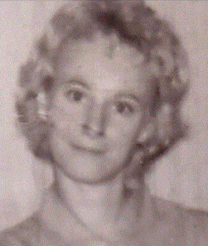 .Phyllis O'Brien Carson
 Interstate 5 bisects French Camp and Yettner Road - and it can be seen here on Google Maps how close both locations are to the main thoroughfare. Both less than half a mile. Almost as though the killer in all the above circumstances is simply passing by these areas via a main highway, that he has traveled many times before - possibly as a result of his profession.
The Modesto abduction of Kathleen Johns, whether or not this has a Zodiac connection, provides the closest link, in that the perpetrator of this crime chose to subject his victim to what appeared to be an aimless drive around the countryside of Tracy, CA, after which she escaped to a nearby field. Where the abductor was ultimately heading may never be known, but Tracy CA, San Joaquin County is a mere 15 to 20 minute drive from Yettner Road and only 15 miles due west from Manteca CA. Therefore, a familiarity with the area remains plausible. This now takes us back to the military connection.
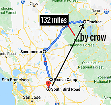
Running right by NASA Crows Landing is Interstate 5, which then intersects with Highway 132 only 24 miles north - a journey of 22 minutes by car. In fact, Interstate 5 joins Highway 132 (the route Kathleen Johns fatefully took that night) only 0.8 miles shy of where she was abducted and ultimately where her car was found burnt out, near Bird Road.
'McClellan Air Force Base (1935–2001) is a former United States Air Force base located in the North Highlands area of Sacramento County, 7 miles (11 km) northeast of Sacramento, California. NAS Fallon in Nevada was originally built in 1942 as part of a defensive network to repel a feared Japanese invasion of the west coast. It was soon taken over by the Navy for training use and has been used as such ever since with the exception of the period of 1946 to 1951, during which it was used by the Bureau of Indian Affairs. During the years prior to 1972, the base was known as Naval Auxiliary Air Station and was heavily used during the Vietnam War by various squadrons that rotated through the base before deploying to carriers headed for Vietnam.' Taken from Wikipedia. These military connections run from Patterson in Stanislaus County to the east of Lake Tahoe. NAS Fallon is located just south of Interstate 80.
If the Zodiac Killer was responsible for the Modesto abduction of Kathleen Johns and the disappearance of Donna Lass, are these observations enough to convince us that he is the responsible. These two areas span 160 miles. The question being, did the Zodiac Killer travel from the Bay Area (if he lived there) to simply commit his crimes and return - or was he likely stationed at any one of these military bases that punctuated Interstate 5 and Interstate 80. His profession may have involved him traveling between these bases, either as a member of the military, a supplier to the military or an independent contractor, but nevertheless, a profession that created perpetual mobility throughout these areas of California. Interstate 80 and Interstate 5 may have played a role with respect to certain serial killers, but was the Zodiac Killer one of them?
The Modesto abduction of Kathleen Johns, whether or not this has a Zodiac connection, provides the closest link, in that the perpetrator of this crime chose to subject his victim to what appeared to be an aimless drive around the countryside of Tracy, CA, after which she escaped to a nearby field. Where the abductor was ultimately heading may never be known, but Tracy CA, San Joaquin County is a mere 15 to 20 minute drive from Yettner Road and only 15 miles due west from Manteca CA. Therefore, a familiarity with the area remains plausible. This now takes us back to the military connection.
Running right by NASA Crows Landing is Interstate 5, which then intersects with Highway 132 only 24 miles north - a journey of 22 minutes by car. In fact, Interstate 5 joins Highway 132 (the route Kathleen Johns fatefully took that night) only 0.8 miles shy of where she was abducted and ultimately where her car was found burnt out, near Bird Road.
'McClellan Air Force Base (1935–2001) is a former United States Air Force base located in the North Highlands area of Sacramento County, 7 miles (11 km) northeast of Sacramento, California. NAS Fallon in Nevada was originally built in 1942 as part of a defensive network to repel a feared Japanese invasion of the west coast. It was soon taken over by the Navy for training use and has been used as such ever since with the exception of the period of 1946 to 1951, during which it was used by the Bureau of Indian Affairs. During the years prior to 1972, the base was known as Naval Auxiliary Air Station and was heavily used during the Vietnam War by various squadrons that rotated through the base before deploying to carriers headed for Vietnam.' Taken from Wikipedia. These military connections run from Patterson in Stanislaus County to the east of Lake Tahoe. NAS Fallon is located just south of Interstate 80.
If the Zodiac Killer was responsible for the Modesto abduction of Kathleen Johns and the disappearance of Donna Lass, are these observations enough to convince us that he is the responsible. These two areas span 160 miles. The question being, did the Zodiac Killer travel from the Bay Area (if he lived there) to simply commit his crimes and return - or was he likely stationed at any one of these military bases that punctuated Interstate 5 and Interstate 80. His profession may have involved him traveling between these bases, either as a member of the military, a supplier to the military or an independent contractor, but nevertheless, a profession that created perpetual mobility throughout these areas of California. Interstate 80 and Interstate 5 may have played a role with respect to certain serial killers, but was the Zodiac Killer one of them?


 RSS Feed