This article was written by Alex Lewis (Welsh Chappie), whose own site detailing Zodiac suspect Lawrence Kane, can be found here.
Earlier today I came across this Map along with a list of directions beneath it. No Idea if it holds any significance but I'm posting it anyway if for nothing more than it's usefulness as a source.
Earlier today I came across this Map along with a list of directions beneath it. No Idea if it holds any significance but I'm posting it anyway if for nothing more than it's usefulness as a source.
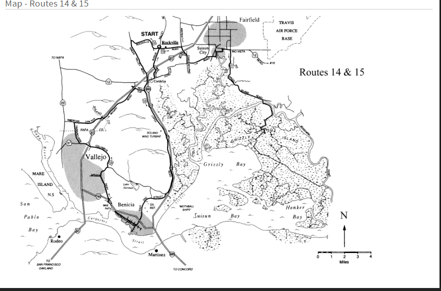
The above map came with the following Directional Instructions:
"This enjoyable figure-eight ride will take you past a high-tech 300-foot wind turbine, the mothball fleet, an oil refinery, and the historic waterfront town of Benicia – all in the first twenty miles. The massive wind turbine was built here for a good reason: wind. May of the trees along the freeway and on the mountain have been sculpted by this tireless force and now look like huge Japanese bonsai. West to east is the prevailing wind direction, due to the temperature differential between the hot Central Valley and cool San Francesco Bay. It is not always windy here, however. Spring and fall are great times, with many calm days. Be sure to explore First Street in Benicia with restaurants, cafes, antique shops, galleries, and much more.
From the small town of Rockville, take Rockville Road west over the hill where the scars of a stone quarry can be seen. Turn south on Green Valley Road, which narrows to no shoulder. Continue to the I-80 freeway overcrossing where the road name changes to Lopes Road. Follow Lopes Road along the west side of Freeway 680. At mile 10.2 the Solano Wind Turbine is an impressive sight. When the wind generator is operation, the tips of the blades travel about two hundred miles an hour.
Cross Lake Herman Road and begin East Second Street at mile 15.4 with an overlook of the mothball ships at anchor in Suisun Bay (pronounced Soo-soon) to the south. Ascend a small hill overlooking the Exxon oil facility, then descend quickly, cross under Freeway 780, and enter Benicia. Turn west on Military East, then south on First Street, a short distance later. If you want to eat, explore, or rest in a shady park, continue downtown form here and rejoin the route later. If not, turn west on K Street and continue to the entrance of Benicia State Recreation Area, and drop down into the parking lot. Follow the bike path, which exits from the far end of the lot. At the end of the path, turn north on State Park Road, cross back over the 780 Freeway and continue north on Columbus Parkway toward Vallejo. Veer north again away from Springs Road (watch for this) and climb a short hill. Stay with Columbus Parkway over two more little climbs, past a golf course, and then descend to what looks like a forced entry onto I-80. Have no fear; you’re going across I-80. Just keep taking the left options, not the I-80 east or west onramps, and follow the sign for Highway 37.
Once safely across, merge right, watch for exiting traffic, and continue a bit more to Fairgrounds Drive and turn north at the signal. Stay on Fairgrounds and cross the Napa County line where the road narrows to one lane. Turn east on American Canyon Road at mile 30.2. American Canyon climbs nicely, reenters Solano County, and recrosses I-80. Turn east on McGary Road, which descends for four miles along the south side of the freeway. The wind is often out of the west, which proves cycling is not always uphill and against the wind! At Red Top Road turn east away from the freeway, descend a bit more to Lopes Road, and turn north there. After crossing the tracks, turn east into Cordelia and follow Cordelia Road to Pittman Road. Pittman changes to Suisun Valley Road on the north side of the freeway. Suisun Valley Road will lead you past the Solano County Community College and back to Rockville where a store awaits you.

 RSS Feed